Community project
ESP32 Plane Radar Display
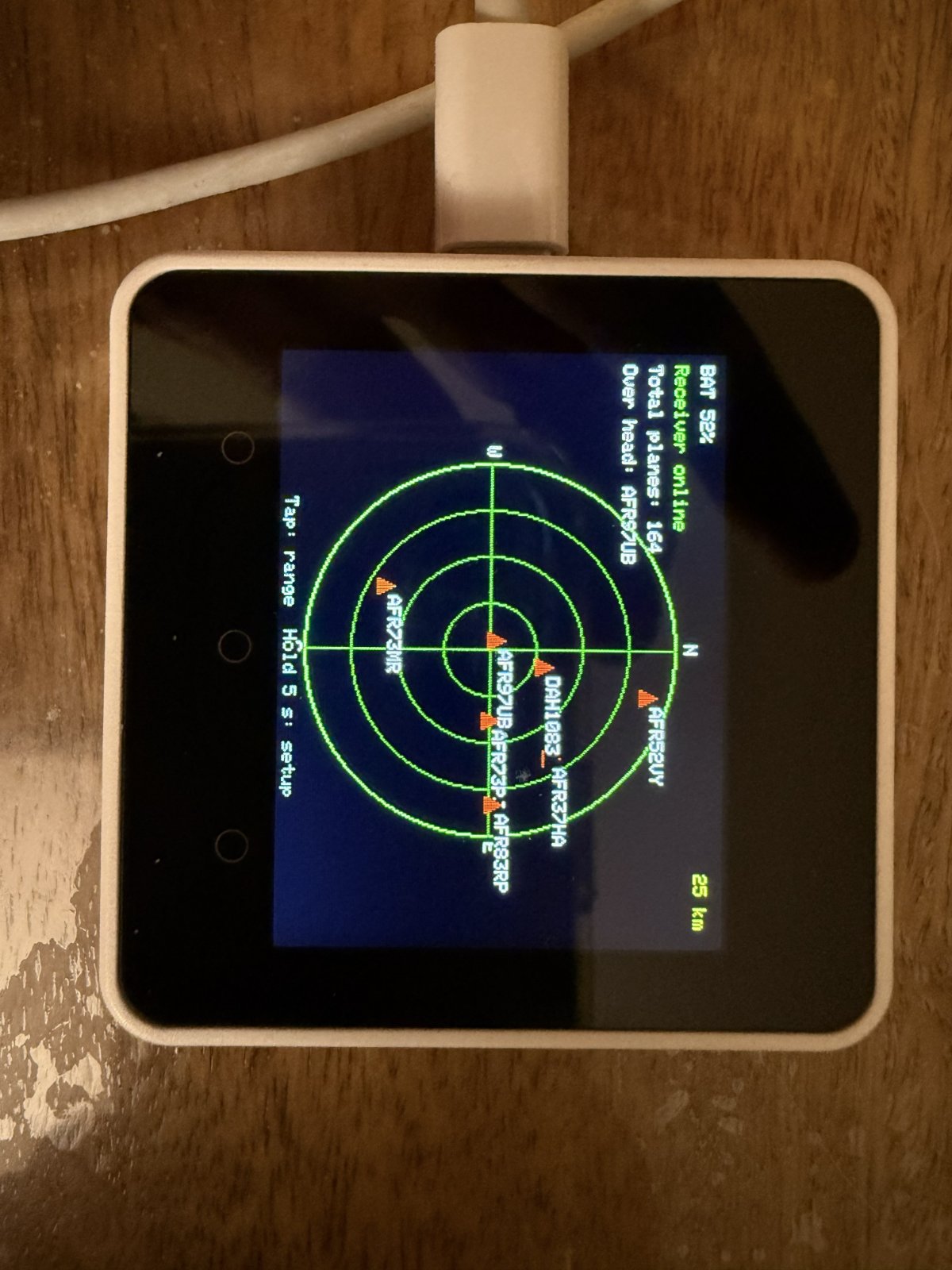
This project turns an M5Stack Core2 into a live aircraft radar display by connecting to a tar1090 ADS-B receiver on the same Wi-Fi network. Aircraft positions are calculated relative to your location and plotted on a circular radar screen with touch controls to adjust the display range.
The guide includes a complete parts list (just the M5Stack Core2), wiring instructions, firmware flashing steps via Schematik Deploy, and setup procedures for entering Wi-Fi credentials and radar center coordinates. Assembly takes minutes—connect the device over USB, flash the firmware, configure your network and receiver, then start tracking planes overhead.
Wiring diagram
Assemble it in 6 steps
1. Use the M5Stack Core2 by itself
The M5Stack Core2 already has the colour screen, touch panel, and battery built in, so do not connect the separate round display or any of its jumper wires. Leave its case closed and place it where you can see the screen.
- The radar uses the Core2’s built-in screen, touch panel, and battery meter.
- Do not connect the old GC9A01 wires to the Core2 — incorrect connections can interfere with the built-in hardware.
2. Connect the Core2 over USB
Plug a USB-C data cable into the Core2 and your computer. The cable supplies power, charges the battery, and lets Schematik send the radar program to the device.
- If nothing happens when you plug it in, try another USB cable because some cables only supply power.
3. Flash with Schematik Deploy
Open Schematik’s Deploy panel and press Deploy to send the radar program to the connected Core2.
- The radar program includes a source-code link to MatixYo’s public ESP32 Plane Radar repository: https://github.com/MatixYo/ESP32-Plane-Radar
4. Enter Wi-Fi, receiver, and location
On first start, join the Wi-Fi network named PlaneRadar-Setup with a phone or computer. In its browser, open http://192.168.4.1. Enter the Wi-Fi name and password used by both the Core2 and ADS-B receiver, the receiver's local IP address such as 192.168.1.50, and the latitude and longitude for the spot you want at the centre of the radar. Press Save and connect.
- Give the receiver a fixed local IP address in your router if possible, so its address does not change later.
- The program automatically reads http://RECEIVER-IP/tar1090/data/aircraft.json; enter only the receiver address, not that full ending.
- You can find latitude and longitude by selecting a location in an online map; values such as 52.3676 and 4.9041 are valid examples.
- The Core2 and ADS-B receiver must be on the same local network — a guest Wi-Fi network may prevent them from seeing each other.
- Enter the minus sign for west longitudes or south latitudes when needed, otherwise aircraft will be plotted around the wrong place.
5. Use the touch controls
Tap the built-in screen once to change the visible distance between 10, 25, 50, and 100 km. Hold one finger on the screen for five seconds to erase saved Wi-Fi details, the receiver address, and the location, then return to the setup page.
- Aircraft data is requested about every five seconds after the Core2 joins your Wi-Fi.
- A short tap changes range; keep your finger down for the full five seconds only when you want to reset setup.
- Holding the screen for five seconds removes the saved Wi-Fi name, password, receiver address, and location, so you will need to enter them again.
6. Check the radar display
The display should show green radar rings, red aircraft markers, a battery percentage at the top left, and receiver status below it. “Receiver online” means the Core2 successfully received and read the tar1090 aircraft data. “Offline” means no data arrived, the receiver replied with an error, or the data could not be read. If it stays Offline, first open http://RECEIVER-IP/tar1090/data/aircraft.json from another device on the same Wi-Fi: it should show aircraft data. Then check the receiver IP address and make sure both devices are on the same local network.
- There are no display jumper wires to troubleshoot because the screen is built into the Core2.
- The Core2 screen, touch controls, and battery meter are initialized by the M5Unified library included automatically by Schematik.
- Do not type the words RECEIVER-IP literally; replace them with the numbers you entered during setup, such as 192.168.1.50.
Deploy the firmware
/*
 * M5Stack Core2 Plane Radar
 * Live ADS-B aircraft from a tar1090 receiver on the same Wi-Fi network.
 * Inspired by MatixYo's ESP32-Plane-Radar:
 * https://github.com/MatixYo/ESP32-Plane-Radar
 *
 * First boot: join PlaneRadar-Setup and visit 192.168.4.1 to enter Wi-Fi
 * and radar-centre latitude/longitude. Tap the screen to cycle range.
 * Hold a finger on the screen for five seconds to clear setup data.
 */
#include <Arduino.h>
#include <M5Unified.h>
#include <WiFi.h>
#include <WebServer.h>
#include <Preferences.h>
#include <HTTPClient.h>
#include <WiFiClientSecure.h>
#include <ArduinoJson.h>
#include <math.h>


// Forward declarations
void message(const char *a, const char *b);
double haversineKm(double lat1, double lon1, double lat2, double lon2);
double bearingDeg(double lat1, double lon1, double lat2, double lon2);
void drawRadarShell();
void drawAircraft(float bearing, float distance, const char *label);
void handleRoot();
void handleSave();
void startPortal();
void fetchAircraft();

constexpr uint32_t FETCH_INTERVAL_MS = 5000;
constexpr uint32_t HOLD_CLEAR_MS = 5000;
constexpr char AP_SSID[] = "PlaneRadar-Setup";
constexpr char NVS_NAMESPACE[] = "planeradar";
constexpr char TAR1090_PATH[] = "/tar1090/data/aircraft.json";
constexpr int SCREEN_W = 320;
constexpr int SCREEN_H = 240;
constexpr int CX = 160;
constexpr int CY = 125;
constexpr int RADIUS = 100;
constexpr double DEG2RAD = M_PI / 180.0;

M5Canvas canvas(&M5.Display);
Preferences prefs;
WebServer configServer(80);
float radarRangeKm = 10.0f;
double radarLat = 0.0, radarLon = 0.0;
String receiverIp;
bool configMode = false;
bool receiverOnline = false;
int totalPlanes = 0;
String overheadCallsign = "---";
uint32_t lastFetchMs = 0, touchStartedMs = 0;
bool touchWasDown = false;

const char CONFIG_HTML[] PROGMEM = R"HTML(
<!doctype html><html><head><meta name="viewport" content="width=device-width,initial-scale=1"><title>Plane Radar setup</title><style>body{font-family:sans-serif;max-width:380px;margin:32px auto;padding:0 16px}input,button{box-sizing:border-box;width:100%;padding:10px;margin:5px 0 14px;font-size:16px}button{border:0;background:#078a42;color:white}</style></head><body><h2>Plane Radar setup</h2><p>Enter the same Wi-Fi used by the ADS-B receiver, its local IP address, and the latitude and longitude at the centre of this radar.</p><form method="post" action="/save"><label>Wi-Fi name</label><input name="ssid" required><label>Wi-Fi password</label><input name="pass" type="password"><label>Receiver IP address</label><input name="receiver" placeholder="192.168.1.50" inputmode="decimal" required><label>Latitude</label><input name="lat" placeholder="52.3676" required><label>Longitude</label><input name="lon" placeholder="4.9041" required><button>Save and connect</button></form></body></html>
)HTML";

void message(const char *a, const char *b = nullptr) {
  M5.Display.fillScreen(TFT_BLACK);
  M5.Display.setTextDatum(middle_center);
  M5.Display.setTextColor(TFT_WHITE, TFT_BLACK);
  M5.Display.setTextSize(2);
  M5.Display.drawString(a, CX, 106);
  if (b) { M5.Display.setTextSize(1); M5.Display.drawString(b, CX, 136); }
}

double haversineKm(double lat1, double lon1, double lat2, double lon2) {
  double dlat = (lat2-lat1)*DEG2RAD, dlon = (lon2-lon1)*DEG2RAD;
  double a = sin(dlat/2)*sin(dlat/2) + cos(lat1*DEG2RAD)*cos(lat2*DEG2RAD)*sin(dlon/2)*sin(dlon/2);
  return 6371.0 * 2.0 * atan2(sqrt(a), sqrt(1.0-a));
}
double bearingDeg(double lat1, double lon1, double lat2, double lon2) {
  double dlon=(lon2-lon1)*DEG2RAD;
  double y=sin(dlon)*cos(lat2*DEG2RAD);
  double x=cos(lat1*DEG2RAD)*sin(lat2*DEG2RAD)-sin(lat1*DEG2RAD)*cos(lat2*DEG2RAD)*cos(dlon);
  return fmod(atan2(y,x)/DEG2RAD+360.0,360.0);
}

void drawRadarShell() {
  M5.Display.fillScreen(TFT_BLACK);
  int batteryPercent = constrain(M5.Power.getBatteryLevel(), 0, 100);
  M5.Display.setTextDatum(top_left);
  M5.Display.setTextSize(1);
  M5.Display.setTextColor(TFT_WHITE, TFT_BLACK);
  M5.Display.drawString("BAT " + String(batteryPercent) + "%", 6, 6);
  M5.Display.setTextColor(receiverOnline ? TFT_GREEN : TFT_RED, TFT_BLACK);
  M5.Display.drawString(receiverOnline ? "Receiver online" : "Offline", 6, 20);
  M5.Display.setTextColor(TFT_WHITE, TFT_BLACK);
  M5.Display.drawString("Total planes: " + String(totalPlanes), 6, 34);
  M5.Display.drawString("Over head: " + overheadCallsign, 6, 48);
  M5.Display.drawCircle(CX, CY, RADIUS, TFT_GREEN);
  M5.Display.drawCircle(CX, CY, 75, TFT_DARKGREEN);
  M5.Display.drawCircle(CX, CY, 50, TFT_DARKGREEN);
  M5.Display.drawCircle(CX, CY, 25, TFT_DARKGREEN);
  M5.Display.drawLine(CX-RADIUS, CY, CX+RADIUS, CY, TFT_DARKGREEN);
  M5.Display.drawLine(CX, CY-RADIUS, CX, CY+RADIUS, TFT_DARKGREEN);
  M5.Display.setTextDatum(top_center); M5.Display.setTextColor(TFT_WHITE,TFT_BLACK); M5.Display.setTextSize(1);
  M5.Display.drawString("N",CX,14); M5.Display.drawString("S",CX,227);
  M5.Display.setTextDatum(middle_left); M5.Display.drawString("W",51,CY); M5.Display.drawString("E",264,CY);
  M5.Display.setTextDatum(top_right); M5.Display.setTextColor(TFT_YELLOW,TFT_BLACK);
  M5.Display.drawString(String((int)radarRangeKm)+" km",310,8);
  M5.Display.setTextDatum(bottom_center); M5.Display.setTextColor(TFT_DARKGREY,TFT_BLACK);
  M5.Display.drawString("Tap: range  Hold 5 s: setup",CX,238);
}
void drawAircraft(float bearing, float distance, const char *label) {
  if (distance > radarRangeKm) return;
  float a=(bearing-90.0f)*DEG_TO_RAD, r=distance/radarRangeKm*RADIUS;
  int x=CX+(int)(cosf(a)*r), y=CY+(int)(sinf(a)*r);
  M5.Display.fillTriangle(x,y-5,x-4,y+4,x+4,y+4,TFT_RED);
  M5.Display.setTextColor(TFT_WHITE,TFT_BLACK); M5.Display.setTextSize(1); M5.Display.setTextDatum(top_left);
  M5.Display.drawString(label, constrain(x+6,0,270), constrain(y-8,0,225));
}
void handleRoot(){ configServer.send(200,"text/html",CONFIG_HTML); }
void handleSave() {
  prefs.begin(NVS_NAMESPACE,false);
  String receiver = configServer.arg("receiver");
  receiver.trim();
  if (receiver.startsWith("http://")) receiver.remove(0, 7);
  if (receiver.startsWith("https://")) receiver.remove(0, 8);
  int slash = receiver.indexOf('/');
  if (slash >= 0) receiver.remove(slash);
  prefs.putString("ssid",configServer.arg("ssid")); prefs.putString("pass",configServer.arg("pass"));
  prefs.putString("receiver",receiver);
  prefs.putDouble("lat",configServer.arg("lat").toDouble()); prefs.putDouble("lon",configServer.arg("lon").toDouble());
  prefs.end(); configServer.send(200,"text/html","<h2>Saved. The radar is restarting.</h2>"); delay(1000); ESP.restart();
}
void startPortal() {
  configMode=true; WiFi.mode(WIFI_AP); WiFi.softAP(AP_SSID);
  configServer.on("/",HTTP_GET,handleRoot); configServer.on("/save",HTTP_POST,handleSave); configServer.begin();
  message("PlaneRadar-Setup","Join Wi-Fi, then open 192.168.4.1");
}
void fetchAircraft() {
  if(WiFi.status()!=WL_CONNECTED || receiverIp.isEmpty()) {
    receiverOnline = false;
    totalPlanes = 0;
    overheadCallsign = "---";
    drawRadarShell();
    return;
  }
  String url = "http://" + receiverIp + TAR1090_PATH;
  HTTPClient http; http.begin(url); http.setTimeout(4500); int status=http.GET();
  if(status==HTTP_CODE_OK) {
    JsonDocument doc; DeserializationError error=deserializeJson(doc,http.getStream());
    if(!error) {
      JsonArray aircraft = doc["aircraft"].as<JsonArray>();
      receiverOnline = true;
      totalPlanes = aircraft.size();
      overheadCallsign = "---";
      double nearestOverheadKm = 2.0;
      int count=0;
      for(JsonObject plane: aircraft) {
        if(!plane["lat"].is<double>()||!plane["lon"].is<double>()) continue;
        double d=haversineKm(radarLat,radarLon,plane["lat"],plane["lon"]);
        String callsign = plane["flight"] | "";
        callsign.trim();
        if(d <= nearestOverheadKm && !callsign.isEmpty()) {
          nearestOverheadKm = d;
          overheadCallsign = callsign;
        }
        if(d>radarRangeKm) continue;
        const char* label=plane["flight"]|plane["hex"]|"AC";
        drawAircraft(bearingDeg(radarLat,radarLon,plane["lat"],plane["lon"]),d,label); count++;
      }
      drawRadarShell();
      for(JsonObject plane: aircraft) {
        if(!plane["lat"].is<double>()||!plane["lon"].is<double>()) continue;
        double d=haversineKm(radarLat,radarLon,plane["lat"],plane["lon"]); if(d>radarRangeKm) continue;
        const char* label=plane["flight"]|plane["hex"]|"AC";
        drawAircraft(bearingDeg(radarLat,radarLon,plane["lat"],plane["lon"]),d,label);
      }
      Serial.printf("Received %d aircraft, plotted %d aircraft\n",totalPlanes,count);
    } else {
      receiverOnline = false;
      totalPlanes = 0;
      overheadCallsign = "---";
      drawRadarShell();
      Serial.println("tar1090 returned invalid JSON");
    }
  } else {
    receiverOnline = false;
    totalPlanes = 0;
    overheadCallsign = "---";
    drawRadarShell();
    Serial.printf("tar1090 request error: %d\n",status);
  }
  http.end();
}
void setup() {
  auto cfg=M5.config(); M5.begin(cfg); M5.Display.setRotation(1); Serial.begin(115200);
  drawRadarShell(); prefs.begin(NVS_NAMESPACE,true); String ssid=prefs.getString("ssid",""); String pass=prefs.getString("pass","");
  radarLat=prefs.getDouble("lat",0); radarLon=prefs.getDouble("lon",0); receiverIp=prefs.getString("receiver",""); prefs.end();
  if(ssid.isEmpty() || receiverIp.isEmpty()) { startPortal(); return; }
  message("Connecting to Wi-Fi...",ssid.c_str()); WiFi.mode(WIFI_STA); WiFi.begin(ssid.c_str(),pass.c_str());
  uint32_t started=millis(); while(WiFi.status()!=WL_CONNECTED && millis()-started<15000) delay(100);
  if(WiFi.status()!=WL_CONNECTED) startPortal(); else drawRadarShell();
}
void loop() {
  M5.update();
  if(configMode) { configServer.handleClient(); return; }
  bool down=M5.Touch.getCount()>0;
  if(down&&!touchWasDown) { touchStartedMs=millis(); touchWasDown=true; }
  if(!down&&touchWasDown) {
    uint32_t held=millis()-touchStartedMs; touchWasDown=false;
    if(held>=HOLD_CLEAR_MS) { prefs.begin(NVS_NAMESPACE,false); prefs.clear(); prefs.end(); message("Setup cleared","Restarting..."); delay(500); ESP.restart(); }
    else { radarRangeKm = radarRangeKm==10?25:radarRangeKm==25?50:radarRangeKm==50?100:10; drawRadarShell(); lastFetchMs=0; }
  }
  if(millis()-lastFetchMs>=FETCH_INTERVAL_MS) { lastFetchMs=millis(); fetchAircraft(); }
}
Remix this project
Make it yours in one click
Open a full copy of this project in your own Schematik workspace — diagram, code, parts, and assembly steps included. Swap the sensor, add features, or redesign the whole thing with AI. The author's original stays untouched.